Schubert, Ciesielski, Stevens, and Kuo (1991) show that a heat source characteristic of an off-equatorial ITCZ draws most of its inflow and discharges most of its outflow on its equatorial side. In the eastern Pacific, the mountains of Mexico and Central America present an additional barrier to tradewind flow into the ITCZ from the Caribbean Sea and the Gulf of Mexico. To characterize the inflows and outflows associated with the east Pacific ITCZ, we should therefore look primarily to the south of the ITCZ in the near-equatorial region. EPIC2001 focuses particularly on the evolution of atmospheric boundary layer (ABL) structure in the ITCZ inflow as the southern hemisphere ABL air moves across the oceanic cold tongue, the near-equatorial SST front and into the region of deep convection.
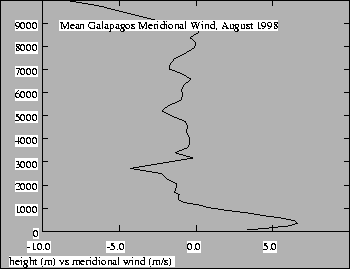 |
Figure 5 shows the mean meridional wind at the Galapagos
Islands (
![]() ,
,
![]() )
for August 1998.
This sounding is characteristic of the summer months over the
Galapagos. Note that the meridional wind is light except at very low
and very high levels. A strong southerly jet exists below
)
for August 1998.
This sounding is characteristic of the summer months over the
Galapagos. Note that the meridional wind is light except at very low
and very high levels. A strong southerly jet exists below
![]() ,
and a northerly jet is found above
,
and a northerly jet is found above
![]() .
These
jets presumably are the low level inflow and high level outflow
associated with ITCZ convection.
.
These
jets presumably are the low level inflow and high level outflow
associated with ITCZ convection.
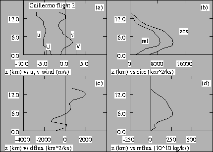 |
Figure 6 shows vertical profiles of various
wind-related quantities in a tropical depression in the east Pacific
ITCZ. These observations were obtained using airborne Doppler radar
during the TEXMEX project. Panel (c) of this figure shows the
detrained volume flux profile of the entire region of deep convection
associated with this depression. Notice that in contrast to the
shallow southerly jet characteristic of the equatorial region, air
flows into this system in a layer about
![]() deep.
Furthermore, the meridional wind in this system does not show the
strong low level jet which exists over the Galapagos.
deep.
Furthermore, the meridional wind in this system does not show the
strong low level jet which exists over the Galapagos.
Understanding the transformation of the shallow low level jet near the
equator into the observed deep inflow layer of ITCZ disturbances is a
central problem for this region. This transformation may be similar
to the transformation of the subtropical marine layer into the
tradewind layer and thence into deep convection which occurs over the
major ocean basins. However, the evolution of the cross equatorial
flow in the Pacific case is highly compressed due to the strong SST
gradient there, with the equivalent transformation taking place over a
fetch of only
![]() .
Furthermore, unlike the
tradewind case, the airmass transformation takes place near the
equator where geostrophic constraints on air motion are weak.
.
Furthermore, unlike the
tradewind case, the airmass transformation takes place near the
equator where geostrophic constraints on air motion are weak.
Theory and fragmentary observations suggest that the vertical structure of the ABL must change significantly across the cold tongue and into the ITCZ region. Observations show that the maximum in the meridional surface wind occurs to the north of the equator, rather than over the coldest water. Wallace et al. (1989) hypothesize that SST gradients and the associated stability effects are important factors in determining the surface wind field and its vertical structure. Bond's (1992) analysis of ABL soundings from a single cross equatorial ship cruise is consistent with this hypothesis, showing that the air over the cold tongue is more gravitationally stable and has greater vertical shear than the air over the SST front and the ITCZ region to the north of the equator.
From a theoretical perspective, Mahrt (1972a,b) demonstrates that near-equatorial boundary layers characteristic of the eastern Pacific ITCZ inflow can have complex vertical structures that are sensitive to pressure adjustments caused by the convergence of turbulent fluxes in the boundary layer and the effects of latent heat release in convection. A peculiar feature of the flow is that it carries negative absolute vorticity across the equator into the northern hemisphere, resulting in the possibility of inertial instability and unbalanced meridional acceleration to the north of the equator (Tomas and Webster, 1997; Tomas, Holton, and Webster, 1999).
More extensive observations of the evolution of ABL vertical structure are needed to determine which physical mechanisms are most important. At this point, it is not clear whether the thickness of the ITCZ inflow layer is due to the depth of the heating in ITCZ disturbances, the deepening due to deceleration of cross equatorial ABL flow as it approaches the ITCZ, or deepening due to the entrainment of air from above. EPIC2001 will address these issues.
Finally, the surface wind stresses and the effects of cloudiness on surface solar and infrared radiation are factors which are important to ocean dynamics in this region. Boundary layer cumulus clouds characteristic of air-mass transformation regimes have been observed from ships and satellites in the vicinity of the SST front to the north of the cold tongue (Deser et al., 1993), and boundary layer clouds are expected to play an important role in the ITCZ heat and moisture budgets. The effects of these clouds, as well as the effects of stratification and stability on wind stress, need to be quantified.