 |
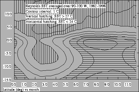
As illustrated in Figure 1, during March the sea surface
temperatures (SSTs) near
![]() are nearly symmetric
about the equator, with
are nearly symmetric
about the equator, with
![]() water being
found between
water being
found between
![]() and
and
![]() .
Waters
are slightly cooler on the equator as a result of equatorial
upwelling. This upwelling becomes stronger from April onward,
resulting in significant additional cooling on the equator.
Subsequently, cooling rapidly spreads into the southern hemisphere, as
a result of a poorly understood mix of oceanic processes. Maximum
SSTs occur in the northern hemisphere in May in a region we call the
east Pacific warm pool, with a gradual cooling trend which
persists until the following February. At this point southern
hemisphere waters abruptly warm in conjunction with warming on and
north of the equator.
.
Waters
are slightly cooler on the equator as a result of equatorial
upwelling. This upwelling becomes stronger from April onward,
resulting in significant additional cooling on the equator.
Subsequently, cooling rapidly spreads into the southern hemisphere, as
a result of a poorly understood mix of oceanic processes. Maximum
SSTs occur in the northern hemisphere in May in a region we call the
east Pacific warm pool, with a gradual cooling trend which
persists until the following February. At this point southern
hemisphere waters abruptly warm in conjunction with warming on and
north of the equator.
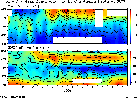 |
Figure 2 shows the depth of the thermocline, as defined by
the
![]() contour, from
contour, from
![]() to
to
![]() along
along
![]() for 1996. Also shown are the
zonal surface winds on this line. The thermocline depth along the
equator is not locally related to equatorial zonal winds at this
longitude, which indicates that transport by equatorial waves
dominates local wind stress-induced upwelling in this region.
However, north of the equator, the thermocline depth appears to
respond promptly to changes in the wind stress curl associated with
meridional variations in the zonal wind. In particular, the
thermocline deepens at
for 1996. Also shown are the
zonal surface winds on this line. The thermocline depth along the
equator is not locally related to equatorial zonal winds at this
longitude, which indicates that transport by equatorial waves
dominates local wind stress-induced upwelling in this region.
However, north of the equator, the thermocline depth appears to
respond promptly to changes in the wind stress curl associated with
meridional variations in the zonal wind. In particular, the
thermocline deepens at
![]() with the onset of westerlies
north of this latitude. The ITCZ is just at the northern limit of the
TAO buoys, but there is an indication that the thermocline becomes
drastically shallower at this time under the ITCZ, presumably as a
result of the associated cyclonic wind stress curl. The overall
shallowness of the thermocline in this region means that the
thermocline depth, the thickness of the ocean mixed layer, and the SST
respond quickly to changes in atmospheric forcing. As a consequence,
the dynamics of the ocean and the atmosphere are tightly coupled by
two-way interactions.
with the onset of westerlies
north of this latitude. The ITCZ is just at the northern limit of the
TAO buoys, but there is an indication that the thermocline becomes
drastically shallower at this time under the ITCZ, presumably as a
result of the associated cyclonic wind stress curl. The overall
shallowness of the thermocline in this region means that the
thermocline depth, the thickness of the ocean mixed layer, and the SST
respond quickly to changes in atmospheric forcing. As a consequence,
the dynamics of the ocean and the atmosphere are tightly coupled by
two-way interactions.
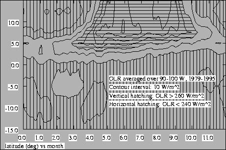 |
The seasonal march of cloudiness and precipitation in the east Pacific
is highly asymmetric about the equator as a result of these
interactions. As is illustrated in Figure 3, significant
northern hemisphere deep convection, indicated by low values of
outgoing longwave radiation (OLR), typically begins in April over the
east Pacific warm pool. Its northern boundary rapidly migrates
northward, while its southern boundary slowly retreats to the north in
close correspondence with the northward march of the
![]() SST contour. The convection cuts off abruptly in late
October or early November. Very little deep convection and
precipitation occurs south of the equator -- what little there is
typically develops in March and April near
SST contour. The convection cuts off abruptly in late
October or early November. Very little deep convection and
precipitation occurs south of the equator -- what little there is
typically develops in March and April near
![]() .
.
The reasons for the highly asymmetric seasonal march of cloudiness and precipitation in the eastern tropical Pacific are the subject of intense current discussion. The most likely ultimate origin of the above asymmetry is the geographical asymmetry of the Central and South American land masses with respect to the equator and its impact on upwelling (Philander, et al., 1996) or on the American monsoon systems (Mitchell and Wallace, 1992; Yu and Mechoso, 1999). Land exists to the north and east of this domain, but not to the south. In addition, the bounding land mass to the east is narrow in the northern hemisphere, but is very substantial in the southern. An understanding of this issue will have to arise through large scale theoretical work as well as atmospheric and ocean modeling, combined with studies such as this one, which are designed to improve model parameterizations of physical processes. Such modeling and theoretical work is underway under the auspices of NOAA's Pan American Climate Studies Program (PACS, 1999) and in other venues. For example, there is some theoretical evidence that the east Pacific asymmetry results from the westward march of the effects of equatorially asymmetric coastal upwelling via a coupled ocean-atmosphere instability (Xie, 1996).
The ultimate goal of the EPIC program is to provide the observational elements required to either verify one of the current theories or contribute to the development of new ones, and thus to validate the performance of coupled ocean-atmosphere global circulation models in this region.
While bearing the above larger picture in mind, EPIC2001 will
concentrate on a more limited domain, namely the atmosphere and ocean
during the late northern summer along
![]() from
from
![]() to
to
![]() and thence southeastward
through the southern hemisphere stratus region. This will allow us to
obtain a detailed picture of oceanic and atmospheric processes at
several latitudes in the problematic region at a time when the
cross-equatorial SST gradient and resulting cross-equatorial
atmospheric Hadley circulation are strong. Under these conditions
rising motion and deep convection occur over the east Pacific warm
pool, while subsidence dominates the region of stratocumulus-topped
cold water to the south.
and thence southeastward
through the southern hemisphere stratus region. This will allow us to
obtain a detailed picture of oceanic and atmospheric processes at
several latitudes in the problematic region at a time when the
cross-equatorial SST gradient and resulting cross-equatorial
atmospheric Hadley circulation are strong. Under these conditions
rising motion and deep convection occur over the east Pacific warm
pool, while subsidence dominates the region of stratocumulus-topped
cold water to the south.