


Next: Project Management Structure
Up: EPIC2001: Overview and Implementation
Previous: Specific Scientific Objectives
As noted above, EPIC2001 will study the atmosphere and the ocean mixed
layer in a north-south section through the east Pacific Hadley
circulation, with an extension into the stratus region to the
southeast. This section will take advantage of the availability of
data from the existing line of TAO buoys along
 .
The number and capabilities of these buoys will be enhanced in time
for the EPIC2001 field phase, which is tentatively scheduled for the
summer of 2001. Enhancements to the TAO buoys include measurements of
precipitation, radiation, and high quality barometric pressure in the
atmosphere and additional oceanographic measurements as well. In
addition, three new buoys are planned so as to extend measurements as
far north as
.
The number and capabilities of these buoys will be enhanced in time
for the EPIC2001 field phase, which is tentatively scheduled for the
summer of 2001. Enhancements to the TAO buoys include measurements of
precipitation, radiation, and high quality barometric pressure in the
atmosphere and additional oceanographic measurements as well. In
addition, three new buoys are planned so as to extend measurements as
far north as
 and to fill a gap at
 (Meghan Cronin, personal communication).
Figure 8:
Schematic illustration of core facilities requested for EPIC2001.
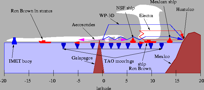 |
The EPIC2001 core effort plans to use two manned research aircraft,
the NCAR Electra and a NOAA WP-3D. These will most likely be deployed
from Huatulco, Mexico (
 ,
,
 ),
with Acapulco, Mexico as an alternate, but somewhat less desirable
base. The Electra will be used to study atmospheric convection as
well as mesoscale atmospheric boundary layer and ocean mixed layer
structure in the ITCZ, while the WP-3D will document the ITCZ inflow
region and ocean mixed layer as far south as the equator. In
addition, pilotless Aerosonde aircraft will be deployed from the
Galapagos Islands (
),
with Acapulco, Mexico as an alternate, but somewhat less desirable
base. The Electra will be used to study atmospheric convection as
well as mesoscale atmospheric boundary layer and ocean mixed layer
structure in the ITCZ, while the WP-3D will document the ITCZ inflow
region and ocean mixed layer as far south as the equator. In
addition, pilotless Aerosonde aircraft will be deployed from the
Galapagos Islands (
 ,
,
 )
to
study the atmospheric boundary layer both north and south of the
equator. A NOAA ship, the Ron Brown, has been requested for
atmospheric and oceanographic measurements in both the ITCZ region and
its inflow, and in the southern hemisphere stratus region. A Mexican
oceanographic ship will be used to deploy drifters in the east Pacific
warm pool, to make atmospheric soundings, and possibly to deploy CORC
floats. An additional ship may be requested to make measurements
within
)
to
study the atmospheric boundary layer both north and south of the
equator. A NOAA ship, the Ron Brown, has been requested for
atmospheric and oceanographic measurements in both the ITCZ region and
its inflow, and in the southern hemisphere stratus region. A Mexican
oceanographic ship will be used to deploy drifters in the east Pacific
warm pool, to make atmospheric soundings, and possibly to deploy CORC
floats. An additional ship may be requested to make measurements
within
 the Ron Brown in the ITCZ in order to
understand the factors which produce small-scale variability in SSTs.
Advantage will be taken of enhanced monitoring of the east Pacific
from TAO buoys on the
line and an IMET buoy to be
deployed in the southern stratus region. The requested facilities are
illustrated in Figure 8.
the Ron Brown in the ITCZ in order to
understand the factors which produce small-scale variability in SSTs.
Advantage will be taken of enhanced monitoring of the east Pacific
from TAO buoys on the
line and an IMET buoy to be
deployed in the southern stratus region. The requested facilities are
illustrated in Figure 8.
The scientific roles of the above-mentioned core platforms are as
follows:
-
NCAR Electra: Survey sea-air fluxes from Mexico south to the south
side of the ITCZ. Make Eldora radar-based convergence boxes in the
ITCZ so as to obtain overall mass fluxes in this region. Make cloud
physical studies of cumulus clouds in the ITCZ using the Eldora radar
and in situ measurements to understand the processes which either
encourage or discourage these clouds to grow into deep cumulonimbus
systems. Deploy AXBTs, ATCTDs, and AXCPs to probe the mesoscale
structure and variability of oceanic temperature, salinity, and
current in the ITCZ in conjunction with the above studies. Survey
temperature, moisture, and wind in the boundary layer while outbound
from Mexico to the ITCZ, and at mid-levels (
 )
from
the ITCZ back to Mexico. Survey convection and stratiform
precipitation on this transect with the Eldora radar. Measure upward
and downward solar and infrared fluxes on both the outbound and return
legs, allowing layer radiative flux divergence estimates to be made.
Measurements will be made through the full diurnal cycle and in all
phases of the easterly wave cycle. About 16 flights, each of
)
from
the ITCZ back to Mexico. Survey convection and stratiform
precipitation on this transect with the Eldora radar. Measure upward
and downward solar and infrared fluxes on both the outbound and return
legs, allowing layer radiative flux divergence estimates to be made.
Measurements will be made through the full diurnal cycle and in all
phases of the easterly wave cycle. About 16 flights, each of
 duration will be required, amounting to about
 of research time. The outbound and return legs together will take
about
of research time. The outbound and return legs together will take
about
 ,
leaving about
,
leaving about
 for studies in and
near the ITCZ. The Electra will operate in close collaboration with
the ship Ron Brown where appropriate.
for studies in and
near the ITCZ. The Electra will operate in close collaboration with
the ship Ron Brown where appropriate.
-
NOAA WP-3D: Document atmospheric boundary layer turbulent fluxes,
structures, and processes from the ITCZ to the equator, and document
the concurrent upper ocean structure. Atmospheric dropsonde
deployments will be made from
 on outbound or southward
tracks along
.
Slow porpoise ABL soundings
between
on outbound or southward
tracks along
.
Slow porpoise ABL soundings
between
 and about
 ,
will be made on
inbound or northward tracks, interspersed with eddy correlation flux
measurements on level tracks at the top and bottom of the boundary
layer. In addition, oceanic AXBTs, AXCTDs, and AXCPs will be deployed
on inbound tracks. The objective of these flights is to observe the
modification of the ABL north of the oceanic cold tongue and the
corresponding structure and evolution of the upper ocean. These
observations will be used in budget studies of ABL mass, momentum,
heat and moisture with emphasis on the role of entrainment and in
studies of oceanic responses to transient atmospheric forcing.
Comparisons will be made between different phases of the diurnal and
easterly wave cycles. Support will also be provided to the NCAR
Electra for some of its ITCZ investigations. Here the NOAA WP-3D will
generally provide large-scale mapping of a convective disturbance on
its southward passage to provide context for finer-scale surveys by
the Electra. A total of about 16 flights, each of approximately
,
will be made on
inbound or northward tracks, interspersed with eddy correlation flux
measurements on level tracks at the top and bottom of the boundary
layer. In addition, oceanic AXBTs, AXCTDs, and AXCPs will be deployed
on inbound tracks. The objective of these flights is to observe the
modification of the ABL north of the oceanic cold tongue and the
corresponding structure and evolution of the upper ocean. These
observations will be used in budget studies of ABL mass, momentum,
heat and moisture with emphasis on the role of entrainment and in
studies of oceanic responses to transient atmospheric forcing.
Comparisons will be made between different phases of the diurnal and
easterly wave cycles. Support will also be provided to the NCAR
Electra for some of its ITCZ investigations. Here the NOAA WP-3D will
generally provide large-scale mapping of a convective disturbance on
its southward passage to provide context for finer-scale surveys by
the Electra. A total of about 16 flights, each of approximately
 duration, or about
 of research time, will be
requested. The outbound leg will take about
to reach the
equator from Huatulco. The return leg will take closer to
of research time, will be
requested. The outbound leg will take about
to reach the
equator from Huatulco. The return leg will take closer to
 due to the lower altitude flown.
-
Aerosondes: Deploy pairs of aerosondes along
,
one proceeding north and the other south of the Galapagos islands,
flying continuous ascents and descents through the ABL. This will
yield a north-south cross-section with high time continuity of the
wind and thermodynamic characteristics of the ABL flow in its
cross-equatorial segment.
-
NOAA ship Ron Brown: The ship will tentatively loiter near (
 ,
)
for 3-4 weeks in order
to document convection and estimate rainfall in the ITCZ using the
ship's C-band Doppler radar, make atmospheric soundings, and to study
mixing processes in the upper ocean. The ship will also cruise south
along
and thence southeast through the east
Pacific stratus region to the IMET buoy at (
,
)
for 3-4 weeks in order
to document convection and estimate rainfall in the ITCZ using the
ship's C-band Doppler radar, make atmospheric soundings, and to study
mixing processes in the upper ocean. The ship will also cruise south
along
and thence southeast through the east
Pacific stratus region to the IMET buoy at (
 ), where atmospheric and oceanic measurements will
also be made. Oceanographic measurements to be made include a program
involving the Modular Microstructure Profiler (MMP). The MMPs carry
air-foil probes for measuring the turbulent dissipation rate, FastTip
thermistors for high-resolution temperature, and SeaBird CTDs for
making temperature and salinity profile measurments. In addition, at
least one will carry an acoustic current meter and a tracking pinger
for shear profile measurements. During the segment through the
stratus and ITCZ inflow regions, a millimeter-wave Doppler cloud
radar, atmospheric lidar, and microwave and infrared radiometers will
be used to remotely sense the characteristics of the clouds. The
C-band Doppler radar will also be used to document the development of
precipitation in the stratus. In addition, sea-air fluxes will be
measured. This transect is considered to be exploratory, to see if
insight obtained in other stratus and stratocumulus regimes can be
applied here.
), where atmospheric and oceanic measurements will
also be made. Oceanographic measurements to be made include a program
involving the Modular Microstructure Profiler (MMP). The MMPs carry
air-foil probes for measuring the turbulent dissipation rate, FastTip
thermistors for high-resolution temperature, and SeaBird CTDs for
making temperature and salinity profile measurments. In addition, at
least one will carry an acoustic current meter and a tracking pinger
for shear profile measurements. During the segment through the
stratus and ITCZ inflow regions, a millimeter-wave Doppler cloud
radar, atmospheric lidar, and microwave and infrared radiometers will
be used to remotely sense the characteristics of the clouds. The
C-band Doppler radar will also be used to document the development of
precipitation in the stratus. In addition, sea-air fluxes will be
measured. This transect is considered to be exploratory, to see if
insight obtained in other stratus and stratocumulus regimes can be
applied here.
-
Mexican ship: From Armando Trasviña:
Our project's main aim is to study the horizontal heat advection in
the upper ocean of the Mexican Warm Pool. The study includes 2 40-day
oceanographic cruises, deployment of about 20+ WOCE-ARGOS surface
drifters and AVHRR imagery analysis.
Our main observation platform will be the B.O. Altair (Mexican Navy).
SSTs from the drifters and other sources will be used to calibrate
(MCSST-like) the AVHRR imagery. Radiative-convective models will then
be used to subtract incoming heat from the SST imagery in
weekly-averaged periods. Images ``rectified'' this way will be
statistically analized to separate mesoscale and large-scale
components of heat advection. Drifter data will be used to validate
results.
The atmospheric component will use these results to improve forcing
mechanisms in climate prediction models.
Both projects will start obervational campaigns in 2001. The
oceanographic project will carry out two 40-day cruises. The first
around May-June and the second around October-November.
The atmospheric project will start deployment of land-based stations
around January 2001. Atmospheric soundings from the ship are also
planned but funding is still uncertain.
-
Additional NSF-sponsored ship: An additional ship will be requested to
make underway oceanographic and atmospheric measurements within 100 km
of the Ron Brown while on station in the ITCZ. The measurements will
include conductivity, temperature, and depth in the upper ocean made
with a Seasoar towed at a speed of 4 m/s on a survey pattern centered
on the Brown. The Seasoar will also measure conductivity
microstructure and in situ optical properties. Additional oceanic
measurements will include horizontal currents with the ship's ADCP and
near-surface temperature and salinity. Meteorological measurements
will be made to accurately estimate air-sea fluxes, including
precipitation, from a combination of direct measurements and a bulk
flux algorithm. The ship will also carry an upward-looking S-band
radar to estimate rainfall. The underway measurements will complement
measurements on the Brown and the nearby TAO mooring by providing
horizontal gradients and their scales of variability.
Data from these facilities will be augmented by long-term monitoring
efforts supported by NOAA's PACS (Pan American Climate Studies)
program, by various satellite remote sensing tools, and by
international efforts associated with the VAMOS (Variability of the
American Monsoon System) project. These include the following:
-
Enhancements to the TAO array at
will consist of
additional moorings at
,
 ,
and
.
All buoys at this longitude will gain
shortwave and longwave radiometers, rain gauges, surface barometric
pressure, extra thermistors, conductivity sensors, and 1-2 current
meters. These observations are critical to achieving the objectives
of EPIC2001.
,
and
.
All buoys at this longitude will gain
shortwave and longwave radiometers, rain gauges, surface barometric
pressure, extra thermistors, conductivity sensors, and 1-2 current
meters. These observations are critical to achieving the objectives
of EPIC2001.
-
Deployment of an IMET mooring at
 ,
,
 is planned with the purpose of studying the energy balance
in the stratus region.
is planned with the purpose of studying the energy balance
in the stratus region.
-
Enhanced soundings will be made from surrounding land areas under
the auspices of PACS.
-
GOES, TRMM, SSM/I, NOAA Polar Orbiting, and other satellite observing
systems will be used in both the operational and data analysis phases
of the project to provide context for the project.
-
The Instituto Mexicano de Tecnologia del Agua (IMTA) in Cuernavaca,
Mexico plans to make meteorological observations in the Isthmus of
Tehuantepec.
-
Instrumented buoys will be placed in the stratus regions of the
eastern Pacific by investigators from Chile.
-
Michael Douglas (personal communication) indicates that radiosonde
soundings will soon be resumed from the Galapagos Islands. In
addition, the wind profiler operated by NOAA's Aeronomy Laboratory
will provide useful information.
-
The ARGO program will deploy profiling floats throughout much of the
Pacific ocean, resulting in ocean soundings to
 .
These
data will provide a useful large-scale context to EPIC2001 ocean
measurements.
.
These
data will provide a useful large-scale context to EPIC2001 ocean
measurements.
Next: Project Management Structure
Up: EPIC2001: Overview and Implementation
Previous: Specific Scientific Objectives
D. J. Raymond
1999-12-13