The RHB has been on station at 10 N 95 W for the entire preceding week. We have been conducting oceanographic and atmospheric operations as planned. The CTD, the MMP (University of Washington modular microstructure profiler), the SPMR (University of California at Santa Barbara solar radiative flux ocean profiler), and the balloon soundings are the primary externally deployed systems in operation. We are doing one CTD (around local noon), about 50 MMP s, about 7 SPMR s, and 6 balloon soundings per day. The success rate for winds on the balloon soundings is very good (about 5/6). We have also been capturing one or two SEAWIFS overpasses every day around noon. On September 19 we began a schedule of XCP (expendable current profiler) drops every 8 hours.
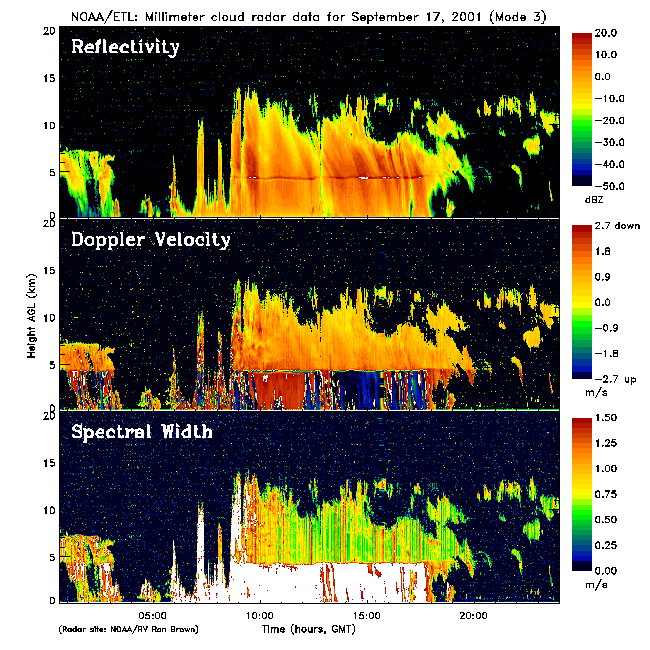
In the past week the weather has gone through a complete cycle from suppressed conditions with strong heat input to the ocean, to strong convection and cooling of the ocean, and back to heating again (see Figure 1 ). Figure 2 shows the corresponding time series of ocean and air temperatures. Two water temperatures are shown: one (blue circles) is very close to the surface while the other is 5-m deep. When winds are light and it is sunny, the surface temperature is much warmer (days 257-258); the cold spikes (days 259-262) are caused by rain during the convective period. At the ship we recorded about 175 mm of rain during this 3-day period. The large cool events in air temperature are caused by cold-air outflows from deep convection. Another interesting aspect is the large diurnal cycle of cloudiness and convection with the peak being just after midnight (LDT); about 3/4 of our rain accumulation has come at night. Figure 3 from the 35 GHz cloud radar shows the precipitating system from day 260 (September 17, 2001). The upper panel is the scattering intensity and the middle panel the fall velocity of the precipitation. You can see the transition from snow/ice to rain at about 5 km. Most of the rain at the ship came from the innocuous-looking spike at about 0700.
Sampling being performed by the UCSB group is proceeding as planned. To date they have collected more than 70 profiles (to 100 m; ~8 per day) of in-water solar radiation data, along with coincident surface irradiance data. A dozen CTD/rosette casts have been performed to 300 m. Water samples collected during each days CTD have been analyzed for chlorophyll concentration and frozen for nutrient analysis back at the UCSB lab. They have successfully collected high resolution SeaWiFS data daily using the ships TeraScan system. The data show a mixed layer depth near 30 meters. A large temperature gradient exists beneath the mixed layer (~12C decrease over 20 meters). Chlorophyll values are less than 0.2 mg m-3 within the mixed layer. A chlorophyll maximum near 0.6 mg m-3, at a depth of ~50m, persisted during the first 6 days of sampling. More recently the chlorophyll maximum has decreased to 0.3 mg m-3 and is found just beneath the mixed layer (near 30 m). Spectral diffuse attenuation coefficients computed from the in-water solar data show biologically-induced changes in solar transmission. The UCSB group is presently working to compute time series of solar transmission.
Mike Gregg reports mostly weak turbulence from the MMP data, with some hints of increased mixing and a deepening of the thermocline in the last few days. The thermocline is very shallow, so they are doing some further processing to try to dig out these small effects.
Amparo Martinez reports continued good measurements with the air aerosol/chemistry system except for SO2. Good phytoplankton samples have also been obtained. The chromatograph continues to have problems, so there have been no reliable DMS results as yet. Samples are still being stored for possible later analysis.
The CSU group is getting good C-band radar data and balloon launches are going very well (see their separate daily reports on JOSS). The cloud radar/microwave radiometers are fully function; the upward pointing IR is still down for lack of a power supply. The mini-MOPA lidar is operating almost about 60% of the time, distributed through the day. Range performance for doppler is 4-6 km and for water vapor is 0.5-1.0 km depending on aerosol and humidity.
The AOML underway pCO2 system was not operating correctly. After consulting with Bob Castle, it was fixed by the ship s chief survey technician Jonathon Shannahof.. Presently showing water CO2 concentrations about 400 ppm vs 370 ppm for the atmosphere.
General Status report on Measurement Systems for September 14 - 21

1      Air-sea flux system                  99%
2      Solar and IR fluxes                 100%
3      Bulk meteorology                    100%
4      Ceilometer                          100%
5      0.92 GHZ wind profiler               95%
6      Raingauges (4 epic)                 100%
7      35 GHZ cloud radar                  100%
8      20, 31 Ghz radiometers              100%
9      90 GHZ radiometer                   100%
10     IR thermometer (upward)              Out
11     Mini-MOPA Doppler/H2O lidar         100%
12     Aerosol and air chemistry            75%
13     MMP                                 50/day
14     SPMR                                 8/day
15     Rawindsondes: thermodynaics          6/day
16     Rawindsondes: winds                 ~5/day
17     C-band Doppler radar                100%
18     CTD                                  1/day
19     ADCP                                100%
20     Terrascan                           100%
21     IMET                                100%
22     SCS                                 100%
23     Thermosalinograph                   100%
24     AOML CO2 system                      25%
25     Flourometer                            ?
26     CIRMS (APL IR SST)                  100%
27     APL 2-m sea temperatuere            100%
28     Portable radiation package (BNL)    100%
Figure Captions:
Figure 1. Time series of daily averaged net heat flux to the ocean for the first 8 days at 10 N 95 W.
Figure 2. Time series of air (red line) temperature and near-surface ocean temperature (blue circles, 5 cm depth; green line, 5 m depth) for the first 8 days at 10 N 95 W.
Figure 3. Time height cross-sections from the ETL cloud radar on September 17, 2001. The upper is the backccatter intensity (dBZ); middle panel the Doppler vertical velocity; and the lower panel the Doppler width.